THE COURSE
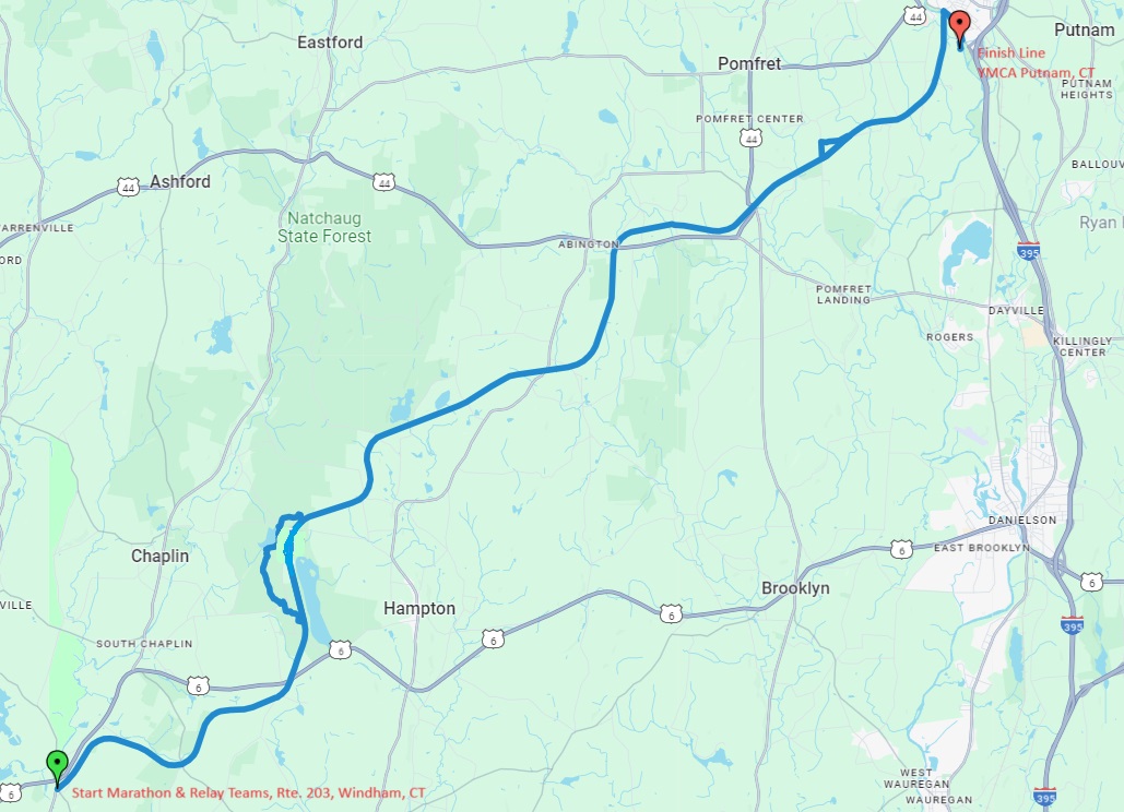
Leg 1: 6.5 miles
Rte. 203, Windham, CT
Leg 2: 4.1 miles
Hampton, CT
Leg 3: 5.3 miles
Hampton, CT
Leg 4: 4.1 miles
Pomfret, CT
Leg 5: 6.2 miles
Pomfret, CT
Putnam, CT
Leg 1: 6.5 miles
Rte. 203, Windham, CT
Start: Rte. 203, Windham, CT
End: Estabrook Rd, Hampton, CT
Road Crossings:
Chewink Rd. (Chaplin)
South Brook St. (Hampton)
Culvert – Trail goes under Rt 6 (Hampton)
Potter Rd (Hampton)
Elevation:
Minimum Elevation: 290 feet
Maximum Elevation: 641 feet
Description: Airline Trail
Leg 2: 4.1 miles
Hampton, CT
Start: Estabrook Rd., Hampton, CT
End: Estabrook Rd, Hampton, CT
Road Crossings:
Estabrooks Rd. (Hampton)
11th Section Rd. (Hampton)
Cannon Rd. (Hampton)
1th Section Rd. (Hampton)
Estabrooks Rd. (Hampton)
Elevation:
Minimum Elevation: 609 feet
Maximum Elevation: 769 feet
Description: Technical Loop in Goodwin Forest
Leg 3: 5.3 miles
Hampton, CT
Start: Estabrook Rd
End: Brooklyn Rd
Road Crossings:
Estabrook Rd (Hampton)
Station Rd (Hampton)
Old Griffin Hwy (Hampton)
Kenyon Rd (Hampton)
Lewis Rd (Hampton)
Route 97 (Pomfret)
Brooklyn Rd (Pomfret)
Elevation: +222 ft
Minimum Elevation: 612 feet
Maximum Elevation: 688 feet
Description: Flat, Non-Technical, Airline Trail
Leg 4: 4.1 miles
Pomfret, CT
Start: Brooklyn Rd
End: Route 169, Pomfret Trail Head
Road Crossings:
Culvert – Trail goes under Route 44 (Pomfret)
Covell Rd (Pomfret)
Babbitt Hill (Pomfret)
Elevation: +18 ft
Minimum Elevation: 414 feet
Maximum Elevation: 568 feet
Description: Flat, Mixed terrain
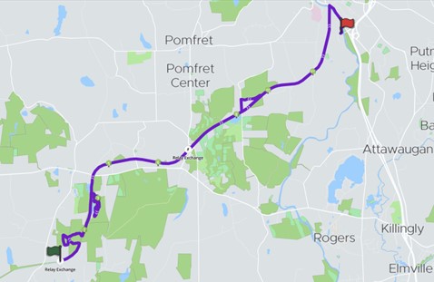
Leg 5: 6.2 miles
Pomfret, CT
Start: Route 169, Pomfret Trail Head
End: Hale YMCA, Putnam, CT
Road Crossings:
Pedestrian Bridge – Trail goes over Route 169 (Pomfret)
Pedestrian Bridge – Trail goes over Needle’s Eye Rd (Pomfret)
Wright’s Crossing (Pomfret)
Holmes Rd (Pomfret)
Culvert – Trail goes under Modock Rd (Putnam)
Culvert – Trail goes under River Rd (Putnam)
Town Farm Rd (Putnam)
Runners will exit the Airline Trail, run over the Henry Breault Pedestrian Bridge, then proceed onto the River Trail, finishing just before the Hale YMCA (Putnam)
Distance: 6.2 miles
Elevation: +259 ft
Minimum Elevation: 256 feet
Maximum Elevation: 455 feet
Description: Some Rough Terrain, Requires Scramble, Airline Trail.
Putnam, CT
Description: Race Festival at the Hale YMCA
Race Festival – Free Beer, Food Massages, SWAG, Live Music and more…
Half Marathon Course
The Tackle the Trail Half Marathon starts in Pomfret, CT and ends in Putnam, CT.
Pomfret, CT
Putnam, CT
Pomfret, CT
Start: Brooklyn Rd
End: Hale YMCA, Putnam, CT
Road Crossings:
- Culvert – Trail goes under Route 44 (Pomfret)
- Covell Rd (Pomfret)
- Babbitt Hill (Pomfret)
- Pedestrian Bridge – Trail goes over Route 169 (Pomfret)
- Pedestrian Bridge – Trail goes over Needle’s Eye Rd (Pomfret)
- Wright’s Crossing (Pomfret)
- Culvert – Trail goes under Holmes Rd (Pomfret)
- Culvert – Trail goes under Modock Rd (Putnam)
- Culvert – Trail goes under River Rd (Putnam)
- Town Farm Rd (Putnam)
- Runners will exit the Airline Trail, run over the Henry Breault Pedestrian Bridge, then proceed onto the River Trail, finishing just before the Hale YMCA (Putnam)
Distance: 13.1 miles
Elevation: +350 ft
Description: Mixed Terrain, Flat Airline Trail Combined With Some Technical Single Track. *Note – There is one very short (2/10ths of a mile), wet portion close to the end of the final leg. Be mindful when navigating course.”
Putnam, CT
Description: Race Festival at the Hale YMCA
Race Festival – Free Beer, Food Massages, SWAG, Live Music and more…
10K Course
The Tackle the Trail 10K starts in Pomfret, CT and ends in Putnam, CT.

Pomfret, CT
Putnam, CT
Pomfret, CT
Start: Route 169, Pomfret Trail Head
End: Hale YMCA, Putnam, CT
Road Crossings:
- Pedestrian Bridge – Trail goes over Route 169 (Pomfret)
- Pedestrian Bridge – Trail goes over Needle’s Eye Rd (Pomfret)
- Wright’s Crossing (Pomfret)
- Culvert – Trail goes under Holmes Rd (Pomfret)
- Culvert – Trail goes under Modock Rd (Putnam)
- Culvert – Trail goes under River Rd (Putnam)
- Town Farm Rd (Putnam)
- Runners will exit the Airline Trail, run over the Henry Breault Pedestrian Bridge, then proceed onto the River Trail, finishing just before the Hale YMCA (Putnam)
Distance: 6.2 miles
Elevation: +259 ft
Description: Some Rough Terrain, Requires Scramble, Airline Trail. *Note – There is one very short (2/10ths of a mile), wet portion close to the end of the final leg. Be mindful when navigating course.
Putnam, CT
Description: Race Festival at the Hale YMCA
Race Festival – Free Beer, Food Massages, SWAG, Live Music and more…
Unique New England
Trail Race